
Not An Easy Task: Using Private Profits to Pay for Public Benefits
Planners and municipalities around the globe have designed and used zoning and density regulatory tools to intensify land development and increase land value. We call this global trend the treatment of land as a source of money. A key driving factor is that financially strained municipalities are looking to extract value from land to support needed infrastructure and services. This kind of public-private land development, commonly referred to as land value capture (LVC), has become commonplace with some planning scholars calling it a new form of public finance. However, using private profits to pay for public benefits is not easy or straightforward. Using LVC effectively requires a hot real estate market and LVC-enthusiastic cities need to navigate the tough task of negotiating the interface between profit logic and public interest. This is the value conundrum that planners, residents, and communities need to face.
In this project, we focus on three common tools in municipal planners’ land use planning toolbox: rezoning, transfer of development rights (TDR), and density bonusing. We investigate the processes and outcomes of their use as well as how these mechanisms shape, and are shaped by public-private land development. Our goal is to shed light on three areas: 1) planning tool mechanisms, 2) public benefits, and 3) impacts on equitable development. We take the equity principle as a point of departure to guide our research because density, as a form of economic rent, shifts costs and revenues between public and private actors, creating important implications for cities and public welfare. By equity, we mean both distributive and procedural justice. The former refers to the need for the recovery of land value increases to further redistributive purposes. The latter refers to the need for a democratic process to consider such redistribution, one that meaningfully engages the public to determine the aim that planning tools serve.
A Case Study Approach
We investigate these three questions using case study methods to develop in-depth and grounded understanding of public-private land development. We juxtapose two dissimilar cases as a method of comparison to shed light on broader lessons and insights. Central North in New Taipei City, Taiwan, is a case of farmland deregulation that involves using predetermined, formula-based planning tools to govern the exchange relationship between density increases and land development outcomes. Our analysis finds that when planning interventions and community participation are absent, profit logics reign. Social housing – the public benefit that can most meaningfully address affordability and equity issues – was the least produced. East Midtown in New York City in the United States is a case of enabling selective redevelopment of commercial office buildings in New York’s central business district to maintain global competitiveness. As a response to pushback against perceptions about insufficient stakeholder engagement in a 2013 rezoning process, New York City engaged a more robust set of stakeholders, resulting in 2015 and 2017 rezonings that include a set of in-kind benefits as well as funds for public realm improvements including open space. Each case builds a detailed account of the tools used and the outcomes, including buildings, infrastructure, facilities, services, and agreements.
Central North: Farmland Rezoning and A Missed Opportunity for Greater Public Benefits
In 2013, New Taipei City, located in the Northern part of Taiwan, rezoned and deregulated 98 acres of privately owned farmland—that includes Central North—to allow residential development (Figure 1). Even though earlier attempts to remove Central North’s farmland zoning status did not move forward because of concerns about food security and environmental protection, municipalities have been rolling out large-scale, high-density, profit-oriented land development projects targeting farmland, urban neighborhoods, industrial sites, and riparian areas since the late 1990s. The rezoning of Central North is not a single case, as there are at least nine other farmland rezoning and development projects in the city, covering 765 acres and in various planning and development stages. Rather, it epitomizes how investment in the real estate market has expanded into previously protected farmland.
At the time of writing, 32 projects in Central North are complete, and 13 are in various planning stages. We focus on those 32 projects for which we collected comprehensive data. To our knowledge, no other study has used administrative and archival records to build a comprehensive dataset to answer questions about land development intensification.
TDR and density bonusing are two planning tools that government planners have designed and deployed to resolve planning issues, achieve planning aspirations, or address public needs, all through more intensified land development. As the following discussion details, the tools’ mechanisms are based on predetermined formulas that dictate the exchange relationship of what developers are required to do to receive additional density. This is often referred to as a rule-based LVC mechanism, in contrast to case-by-case negotiations involving multiple parties, such as community residents, developers, municipal planners, and local council members. TDR and density bonusing are so widely used that they are almost a standard practice in land development in Taiwan. Our analysis is a window into their mechanisms and outcomes, shedding light on the interaction between public benefits (or lack thereof), private profits, and planning tools.
Figure 1. Central North and its location in northern Taiwan
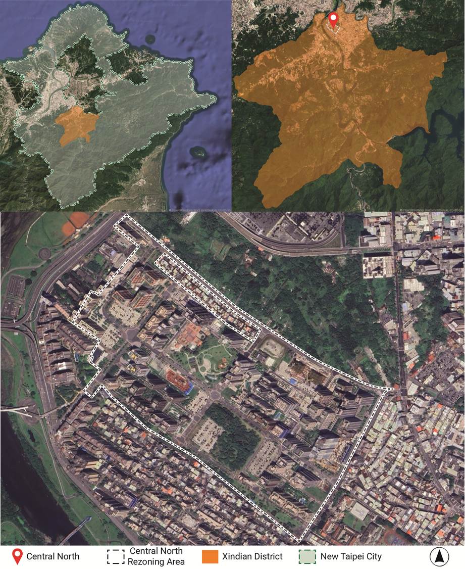
Source: Open Government Data of New Taipei City. Imagery © 2026 Google, Airbus Data; SIO, NOAA, U.S. Navy, NGA, GEBCO, Landsat / Copernicus.
TDR: The Reserved Land Issue, a Political Expediency, and a Normalized Market Practice
At its simplest, TDR is a technique of fungible air rights. Air rights are the development potential the zoning code allows for a given land parcel, governing building height or floor area. Local authorities may restrict certain lands from development, such as to preserve historical landmarks or ecologically sensitive areas; TDR allows unused air rights to be spatially transferred elsewhere.
In Taiwan, TDR was first introduced in urban planning in the 1980s after government officials learned about, and were inspired by, New York City’s use of TDR to preserve Grand Central Terminal as a historical landmark. However, it is the “reserve land issue (baoliude wenti, 保留地問題)” that has become the primary driver of the widespread use of TDR today. The “reserve land issue” had its historical roots in colonial planning during Japanese rule (1895–1945) and continued to worsen under rational planning under the authoritarian state in postwar Taiwan. The issue refers to thousands of acres of privately owned land parcels that were designated for public use—such as parks, schools, and roads—and stripped of development potential. Meanwhile, thousands of affected landowners have yet to receive compensation because municipalities have been either too financially constrained or have chosen other spending priorities. In 2013, the estimated total amount of reserve land in Taiwan was over 61,000 acres (Shih and Change, 2016). As democratization accelerated in the late 1980s, the reserve land issue escalated into a political crisis that needed to be quickly addressed.
In the mid-1990s, New Taipei City, which had the largest number of reserve land parcels, became the first municipality to experiment with TDR as a response to the reserve land issue. At the core of the mechanism is a formula that calculates the development rights (in floor area) that “belong to” a reserve land parcel. TDR allows property developers to build higher density elsewhere in the city if they purchase reserve land parcels from affected landowners and donate those parcels to the local government, effectively terminating the limbo in which those parcels are caught. In the TDR market, private property developers almost always have an upper hand because there are thousands of affected landowners whose only option is to sell their reserve land parcels to developers or land brokers (Shih and Change, 2016).
TDR is a crucial generator of intensified land development. But because TDR is treated as a deal between two trading parties and does not include community participation, local residents are unaware of higher-density development, or why development is denser, until after the fact.
The Bordeaux II project illustrates this well. Density is a form of economic rent and more salable units means a greater profit margin. To maximize financial returns, developers almost always transfer development rights from multiple reserve land parcels, which are often small, into a project. The Bordeaux II transferred 86,687 sf of extra buildable floor area from 46 reserve land parcels scattered throughout the larger area (Figure 2). Financially, it is well known that developers make a profit by paying low for reserve land and selling apartment units built from TDR at a high price. Politically, local authorities are motivated to keep TDR afloat as a fix to the reserve land crisis. As a result, local authorities also have a vested interest in keeping the real estate market hot. Designed to be a highly flexible and relatively low-cost tool for the real estate sector, TDR has been a widespread practice in land development in Taiwan.
Figure 2. TDR and the relationship between reserve land parcels and development sites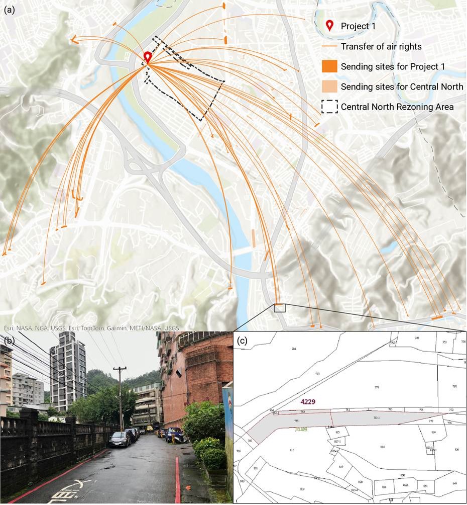
Panel (a): Project 1 (The Bordeaux II) received 86,687 sf of extra density through TDR from 25,758 sf of reserve land parcels-sending sites. There were 62 recorded transfers from the 46 reserve land parcels, indicating that some reserve land parcels were broken into fractions and multiple transfers occurred. Panels (b) and (c): A street-level photograph for parcels numbered 4229-782 and 4229-783 and their cadastral map (shown as a grey polygon). This reserve land parcel underwent five transfers, as indicated by the multiple orange lines connecting it and the development site in panel (a).
Source: The Urban and Rural Development Department, New Taipei City; New Taipei City Urban-Rural Info (https://urban.planning.ntpc.gov.tw/NtpcURInfo/). Image credit: Wei-ying Chen, 2026.
Density Bonusing: A Profit Booster That Embeds Planners’ Values
Density bonusing is a mechanism that grants developers higher density in exchange for privately funded contributions for the public. Because density is economic rent, this tool, similar to TDR, makes development finance more favorable while intending to recover some fraction of the land value increase to pay for things that are beneficial to the city. The key question that planners, residents, and community organizers need to ask is who decides what things are “beneficial” to the public, how do they decide, and through what processes. As literature on LVC and equity reminds us, equity is both about furthering redistributive outcomes, e.g., addressing the disadvantaged and their needs, and democratic processes, e.g., meaningful public participation so that differences and alternatives also thrive.
In Central North, there are four types of density bonusing available for land development intensification: Large-Site Development (damianji kaifa, 大面積開發), Green Building (lujianzhu, 綠建築), Smart Building (zhihui jianzhu, 智慧建築), and Social Housing (shehui zhuzhai, 社會住宅). Similar to TDR, each measure uses a predetermined formula. Because there is no community participation involved in decision making, each measure reflects planners’ value judgments. Because government planners do not prioritize among these tools, leaving the property developers a free hand in choosing which ones to use and how to combine them, the outcomes also reflect real estate capital’s interests. This lack of procedural equity is crucial to understanding the lack of distributive equity.
The land use ordinance sets a baseline 2.4 FAR in Central North. Large-Site Development grants the most generous density bonus. It gives an additional 15 percent of the baseline FAR if the developer assembles a site larger than 3,000 m2 (32,292 sf) and an extra 10 percent of the baseline FAR for a site greater than 1,500 m2 (16,146 sf). This measure effectively rewards capital-rich and powerful property developers. Mi Shih and Ying-hui Chiang’s work shows that local planners justified this tool on the basis that larger scale land development yields a desirable city form (2024). If the equity principle is to recover land value for the public and those in need, Large-Site Development works against those values.
In contrast, Green Building gives a much smaller incentive—an additional 5 percent FAR—for certified buildings. Smart Building works similarly but at an even lower rate of an additional 3 percent FAR. They are designed with the intention to address energy use and safety issues by addressing building-level improvements. Because Green Building and Smart Building give far less density bonus, these two measures are used less.
To further equity, Social Housing should have been the most impactful. In the past two decades, the housing price to family income ratio, a key affordability metric, worsened nearly twofold from 6 percent to about 12 percent in New Taipei City. Yet, its current mechanism is conservative and reactive—only exempting units built by developers from floor area calculations. As a result, it is little used by developers. Given that the affordability challenges disproportionally affect low-income families and younger generations, Social Housing in its current form is a missed opportunity to build more equitable development.
Market Capture of Land Value
It is now clear that these density-based tools introduce a new calculus of development finance. It is therefore crucial to ask: how much buildable density in excess of FAR limits has the city granted to developers? Which planning tools do developers use most? What has the city received in return? Are they public benefits? Do these tools further the equity principle? These are questions applicable to any LVC practice. Our analysis sheds important light on these questions. A key finding is that the city has left the public benefit that matters the most to equity – social housing – to market vicissitudes. This is a real problem.
The tool most profitable to developers is the most often used
Between 2004 and 2021, the four density bonusing measures granted 934,829 sf of additional buildable floor area. Together, Large-Site Development (51 percent) and TDR (32 percent) account for a total of 83 percent of all density granted. Green Building, Social Housing, and Smart Building account for the remaining 17 percent. Large-Site Development and TDR are the most popular tools because they generate the most profit while requiring no meaningful public benefits in return. This is market capture, rather than public recovery, of land value.
Social housing was given short shrift
To hold planning tools accountable, it is important to examine their private profit-public benefit exchange relationship. To do so, we juxtapose the additional floor area each project received and the contributions it produced (Figure 3).
In Figure 3, each bar represents floor area, either the additional density received (on the right) or the contribution produced (on the left); each circle on the left indicates the hard-to-quantify urban feature that a tool created. For example, Project 1 (The Bordeaux II) received 130,030 sf from TDR (86,687 sf, or 67 percent), Large-Site Development (32,508 sf, or 25 percent), and Social Housing (10,836 sf, or 8 percent), enlarging the project’s profit margin by adding more salable units (also see Figure 4). In return, Project 1 purchased 25,758 sf of reserve land (light orange bar) to receive TDR and built 20 units of social housing (light blue bar). A light yellow circle indicates that Large-Site Development (as well as Green Building and Smart Building in other projects) does not produce something in a physical sense, but rather, a feature or a quality.
In Central North, the public-private relationship created by these density-based planning tools is far from even or equitable. In total, 46 units of social housing are produced by three projects. Yet, Central North is one of the most expensive housing markets in New Taipei City. While green buildings may be justified for goals of climate resiliency and energy efficiency, it is not clear why smart buildings, let alone large-scale development projects, should be incentivized by planning tools or take priority over social housing production. When planning tools work as a reliable profit booster for the real estate market yet only require little or uncertain return of public benefits, they diminish the equity principle.
Figure 3. Public-private exchange relationship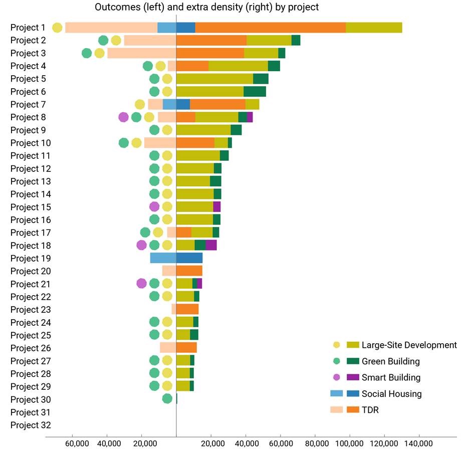
Note: To the left, each bar represents the floor area of the outcome that the corresponding tool produced, each circle represents a non-quantifiable feature or quality that is produced. Unit: square feet.
Source: Meeting minutes published by the Urban Planning and Design Review Committee, New Taipei City Government, downloaded from https://www.planning.ntpc.gov.tw/home.jsp?id=502f4edfb925e407. Data on reserve land areas are from the Urban and Rural Development Department, New Taipei City.
Figure 4. The Bordeaux II and intensified land development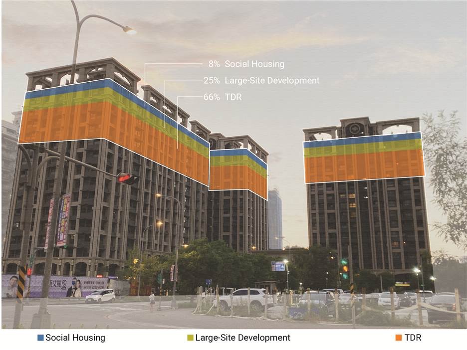
Note: Percentages indicate each density bonusing measure’s share of the total additional buildable floor area granted to Project 1 (130,030 sf). In total, they enabled the developer to construct approximately four additional stories. The social housing units provided by Project 1 are actually located on the second and third floors; the “Social Housing” width shown in blue here is for illustrative purpose only to highlight the intensification of development enabled by the density bonusing measures.
Source: Meeting minutes published by the Urban Planning and Design Review Committee, New Taipei City Government, downloaded from https://www.planning.ntpc.gov.tw/home.jsp?id=502f4edfb925e407. Image credit: Wei-ying Chen, 2025. Illustration: Yu Wang.
East Midtown: Future Proofing the Central Business District
East Midtown, one of Manhattan’s historic central business districts, is home to a diverse mix of finance and non-financial companies. Much of the area was developed more than a century ago around Grand Central Terminal. Even though it is a bustling central business district today, many buildings are aging and the area lacks sufficient Class A office space, fueling concern about its long-term global competitive position. Redeveloping properties is challenging because many are more dense than contemporary zoning allows. In 2013, the City proposed to rezone the area but withdrew its initial proposal due to demands for greater stakeholder engagement and transparency about the selection of and timeline for public realm improvement projects, a potential undervaluation of landmark air rights, and concern that the effects of the rezoning could threaten historic properties that were not landmarked (Bagli, 2013; Landauer Valuation & Advisory, 2016). The City launched a more extensive process to gather “stakeholder” feedback, carved out a micro-rezoning of the Vanderbilt Corridor in 2015, and sent a dozen properties through the landmark approval process in 2016 (NYC Landmarks Preservation Commission, 2016). In 2017 it approved the Greater East Midtown rezoning plan, with a larger rezoned area, a “market” price for Landmark TDR, a requirement for open space, and a more transparent and robust process to fund public realm improvements (NYC DCP Zoning Resolution, 2017). Both East Midtown rezonings are generating new development and public realm improvements in the CBD. Next we walk through the details of each rezoning.
Vanderbilt Corridor Subarea Micro-Rezoning
The City rezoned a 5-block portion of Vanderbilt Avenue between East 42nd and 43rd Streets in 2015 to act on the development potential of transit-rich sites on Vanderbilt and Madison Avenues, improve pedestrian infrastructure, and facilitate the transfer of landmarks’ unused development rights (ZR §81-63; City Planning Commission, 2015A). The micro-rezoning includes two density bonus tools. The Special Permit for Grand Central Public Realm Improvements (ZR §81-633) provides a density bonus from a base of 15 FAR to a maximum of 30 for qualifying buildings that negotiate on- or off-site, at- or below-grade pedestrian or transit flow improvement investments near Grand Central Terminal (City Planning Commission, 2015A). The Special Permit for Transfer of Development Rights from Landmarks to the Vanderbilt Corridor Subarea (ZR §81-632) modifies a tool created in 1992 to transfer unused Landmark TDR in the Grand Central core. The rezoning increased the FAR amount landmarks can transfer, removed a requirement for a transit or public realm improvement, and maintains a requirement for a landmark maintenance plan (City Planning Commission, 2015A).
This rezoning has generated one supertall building and another building is on the way. One Vanderbilt opened in 2020 across from Grand Central Terminal. The developer used both rezoning density tools to increase the building’s FAR from 15 to 30 (City Planning Commission, 2015A). It received a special permit for the Grand Central Public Realm Improvement Bonus to increase its FAR by 12.37 (535,644.75 sf) and made $220 million worth of on- and off-site improvements to transit and the public realm in, around, and under Grand Central Terminal (City Planning Commission, 2015B; SL Green Realty Corp., 2020). One block north, the former Metropolitan Transportation Authority (MTA) headquarters is under development through a public-private partnership between the MTA and a developer at 343 Madison Avenue which received approval to increase its FAR from 15 to 30 (376,560 sf) through the Grand Central Public Realm Improvement bonus while producing on- and off-site transit improvements (City Planning Commission, 2021).
Greater East Midtown Subdistrict Rezoning
Following a process with increased stakeholder engagement, the City rezoned a second area – 78-blocks of East Midtown – and increased allowable density on qualifying sites, especially near transit (City Planning Commission, 2017). To enable buildings to reach maximum allowable densities, the rezoning incorporates an as-of-right Landmark TDR tool and two as-of-right density bonusing tools: “Overbuilt” and “Transit Improvement Zones.” Qualifying sites in the Grand Central Transit Improvement Zone Subarea or Other Transit Improvement Zone (TIZ) can complete one or more “Priority Improvement List” transit items that equate to a floor area bonus (ZR §66-511, §66-512, and §81-682). Landmark TDR enables landmarks in the GEM rezoned area to sell unused development rights to qualifying sites in the rezoned area. A share of Landmark TDR sales is directed to the newly created Public Realm Improvement Fund (PRIF). Participating landmarks need a continuing maintenance plan (NYC DCP, 2017A). The Overbuilt tool enables qualifying sites developed before December 15, 1961, with existing FAR that exceeds allowable FAR, to rebuild more densely in exchange for a PRIF contribution (ZR §81-613; ZR §81-643). The PRIF receives monetary contributions from qualifying sites that use the Overbuilt tool, Landmark TDR, or special permits to modify certain site provisions. A 13-member PRIF board funds improvements that meet pre-determined criteria and were pre-identified in the Public Realm Improvement Concept Plan, including public pedestrian safety improvements and pedestrian flow improvements at transit stations that serve East Midtown (NYC DCP, 2017A; NYC DCP, 2017B; ZR §81-683).
In the GEM rezoned area, qualifying sites can also access two special permits for density in exchange for additional open space or transit improvements. The Special public concourse permit provides up to 3 FAR for an additional onsite public space (ZR §81-645). The Special permit for transit improvements in the Grand Central Transit Improvement Zone Subarea or the Other Transit Improvement Zone Subarea enables qualifying sites to access a FAR bonus for transit improvements if they have already received the as-of-right TIZ bonus (ZR §81-644). The GEM rezoning also requires that developments create up to 10,000 sf of open space (ZR §81-681). Some developments are also rebuilding sectors of the Grand Central Terminal train shed, the rail storage and circulation structure located under Park Avenue (MTA, 2025).
New Sites in Greater East Midtown
The Greater East Midtown rezoning has generated one new building, and four buildings are planned. The sites are using many of the as-of-right and density bonusing tools, completing other GEM rezoning requirements such as creating open space, making contributions to the PRIF and other public realm and transit improvements, and creating other new open space. The development and public realm improvements are all focused on the central business district.
The Landmark TDR tool has finally enabled the owners of the air rights from three large landmarks to sell or plan to sell 1,820,427 sf of air rights (Figure 5). Each of the new development sites is buying landmark TDR. Those purchases are expected to generate about $121 million for the PRIF. For example, 270 Park Avenue is a new 1,388 ft supertall tower. The project used Landmark TDR to transfer 666,766 sf of floor area (8.3 FAR) from the investors of Grand Central Terminal’s air rights at a cost of approximately $208.4 million in 2018. This transaction contributed approximately $41.7 million to the PRIF and $10.4 million for landmark maintenance (NYC DCP, n.d.; NYC DCP, 1991; City Planning Commission, 2019). Two sites are planning to use the Overbuilt tool to rebuild 130,480 sf of non-complying floor area in exchange for an $8 million contribution to the PRIF. Finally, the proposed 175 Park Avenue site which sits over the Grand Central 42nd Street Subway station, used a TIZ special permit to receive 3 FAR (611,616 sf) for Grand Central Station transit improvements (NYCP ZAP).
The GEM rezoning requires that sites larger than 30,000 sf provide a minimum of 10,000 sf of open space (ZR §81-681). 270 Park Avenue included a large open space; the proposed 175 Park Avenue and 350 Park Avenue sites will as well. The GEM rezoning also enables sites to receive a density bonus in exchange for producing even more open space. Three sites – 415 Madison Avenue, 175 Park Avenue, and 350 Park Avenue – are planning to use the Public Concourse special permit. 175 Park Avenue, for example, is planning two additional public spaces to provide views of the historic Graybar building and Grand Central Terminal. They will also add a new Transit Hall to improve pedestrian flow through the Grand Central 42nd Street Subway station (NYCP ZAP). Finally, the MTA formed two public-private partnerships with developers of two sites to rebuild three sections of Grand Central Terminal’s train shed and provide $75 million towards this effort (MTA, 2025).
The two rezonings have enabled the development of new soaring office towers and directed investments into the public realm. The enhanced stakeholder engagement process that resulted in the 2017 rezoning secured more social benefits than originally proposed in 2013. As cities increasingly turn to land development to secure social benefits, new questions emerge about what kinds of processes they use to modify land use rules, who is involved in the processes, and how those involved think about the type, scale, location, distribution and beneficiaries of benefits. These are challenging questions to address, but they are important to think through as land plays an ever more central role in securing social benefits.
Table 1. Completed and planned developments, as of June 2026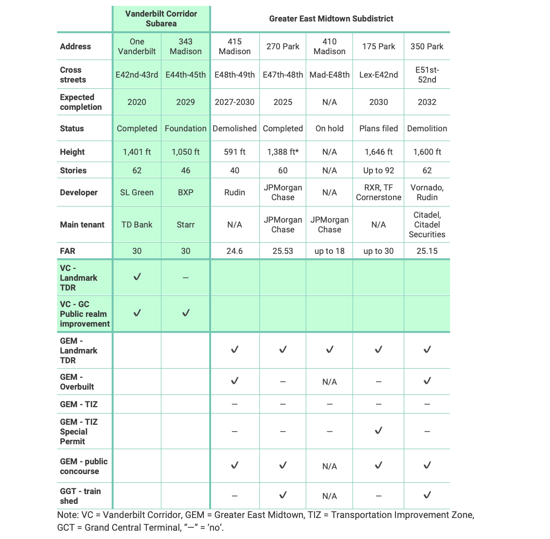
Source: News reports and planning documents (NYCP ZAP and MTA).
Figure 5. Proposed and completed Landmark TDR sales in the Greater East Midtown Subdistrict, as of June 2026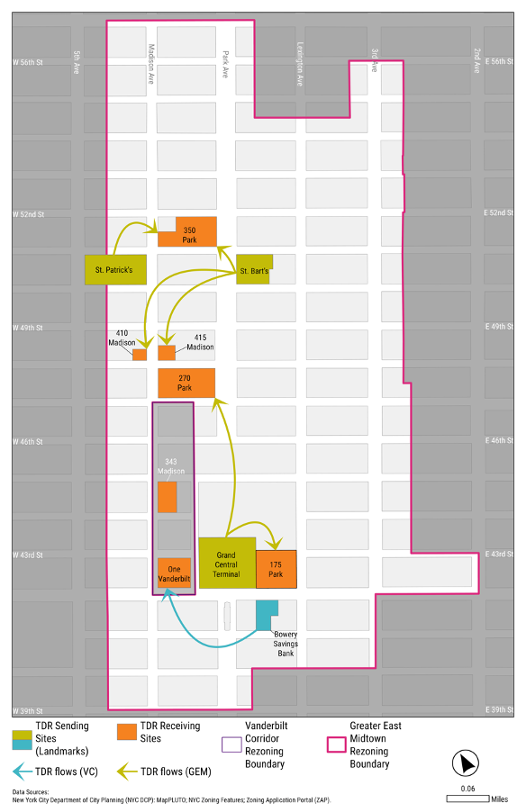
How to Do Better: More Equitable Land Development
Juxtaposing East Midtown and Central North reveals similarities between them—even though they have dissimilar urban histories and contexts—and generates important insights. Both cases achieved the goals of urban spatial economic development that planners intended for their respective areas. The rezoning of East Midtown is New York City’s most recent effort to revamp its historic central business and high-end office district by channeling capital investment into the area; the Central North rezoning represents New Taipei City’s ongoing acceleration and expansion of urban property development by deregulating farmland. There are four key insights and a few recommendations.
- Planning tools are highly generative.
Rather than simply extracting value dormant in land, planning tools actively construct land value and shape the urban built environment. These tools generate revenue by making land legible to capital investment (e.g., deregulating farmland for urban development), creating conditions for marketization (e.g., modifying TDR rules to enable air rights trading), and intensifying land development (e.g., allowing and incentivizing greater FARs). They also use landed revenue to fund new public facilities and infrastructure. Each case builds an inventory of the array of infrastructure, facilities, services, and agreements involved. This shows the heightened centrality of land’s financial and fiscal capacity, as well as how public and private spaces are produced and simultaneously shaped by land intensification. Planning tools are highly generative because of their multiple fiscal, financial, and spatial capacities. Planners and community residents should also be aware of planning tools’ other powerful capacity: that they introduce and set in motion new conditions that impact and even devalue land’s other environmental and social use values. A greater public engagement, debate, and decision-making process is needed when planning tools are used in connection to permanent loss of farmland, green space, and alternative livelihoods.
- To further equity, a more nuanced understanding of “public benefits” is needed.
Lumping the outcomes of planning tools into a single homogenous category of “public benefits,” or in the case of New York City, public realm benefits, masks potential insights about how we might think about this LVC-style land development and equity-related questions. As the two case studies show, there are at least three forms of outcomes from public-private land development. We should ask different questions to investigate implications for equity.
In-kind contributions are the most common form of public benefits, such as social housing in Central North and open space, pedestrian thoroughfares, and transit improvements in East Midtown. We should ask about their scalar effects. Do they serve the wider segments of the population, especially those who are in need or disadvantaged? Or do they target the immediate community in the vicinity of new development or expand capacity to address the needs of the new development? The former is more likely to facilitate redistributive goals and equitable outcomes while the latter can help reduce public expenditures to meet the infrastructure needs generated by the new development but may leave broader equity concerns secondary.
Monetary contributions are also common in LVC practice. It is important to ask, to what use is the monetary contribution put, through what process it is decided, by whom, and who will benefit. These questions situate revenues from intensified land development back to both the redistributive and procedural considerations of equity.
Planning tools also produce urban features or qualities that planners deem important or desirable, such as large-scale development and certified green and smart buildings in Central North. These outcomes are not easily quantifiable, making it difficult to assess their impacts. Here, we want to reiterate the importance of democratic participation and decision-making. When meaningful public participation and engagement are absent, powerful actors, through the use of planning tools, can codify their ideas, values, and interests in the urban built environment and intensified land development. But there are key questions about who gets to participate and to what ends.
- To create a level ground for public-private negotiation, the relationship between “externalities,” “social costs,” and “public benefits” needs further examination.
A level ground for public-private negotiations is crucial to producing public benefits that meaningfully contribute to public welfare. These planning tools should ensure that developers internalize negative externalities, avoiding the problem that the public sector socializes the cost while landed revenue is captured by the private sector. However, it is not easy to examine whether public benefits cover the project’s “fair share of cost.” That municipalities are enthusiastic about using planning tools, but data about the processes, outcomes, and impacts of land development intensification is slow to come by means more attention needs to be paid to tease out the relationship between externalities, social costs, and public benefits in land development. Planners and community residents should ask clarifying questions, such as what impacts and losses are included, counted for, or discounted in the negotiation; how intangibles are recognized; which sector, public or private, pays to offset them, and whether externalities are being mistaken as public benefits.
- Deliberative democracy and public participation should be integral to planning tool design and use.
Planning tools have great potential to create and fund infrastructure, facilities, and services, but what constitutes a public benefit can only be answered through a democratic participation process. As municipalities have mobilized their regulatory power to treat land as a source of revenue and create land’s fiscal capacity, a diverse group of people should also be empowered to participate in this urban governance process that impacts almost all aspects of the city’s urban future. It is important to ask how these planning tools shape how we govern our cities and live our everyday lives. A diverse group of stakeholders and people should be empowered to ask questions about the implications of public-private land development for equity – the intended and unintended consequences and the realized and unrealized opportunities for social betterment.
Recommendations for Future Work
- Planners should assess the full and wide-ranging impacts of land development intensification, especially when rezoning leads to the loss of farmland, green space, and land’s multiple use, environmental, and social values.
- Before employing planning tools to intensify land development, there should be meaningful public participation that engages community residents, especially those whose voices were previously left out. Given the increasing use of these tools to raise revenue for public purposes, that participation might involve a broader geographic group than only those immediately affected by the development.
- There should be a comprehensive overhaul of TDR and density bonusing measures in New Taipei City. An equity-focused framework should guide the examination.
- To facilitate public engagement, more information and data should be widely available to the public and easier to navigate. This includes the use of planning tools; granting of additional density and estimates of the market value enabled by it; types, locations, and conditions of public benefits, and terms and details of public-private negotiations.
- There should be a user assessment of in-kind public benefits, such as open space, sidewalks, and social housing units, to determine their accessibility and service. Once produced, it is critical they are accessible and well-maintained.
Sources
Bagli, Charles V. (2013, November 12). Support evaporates for Bloomberg’s plan to rezone East Side. The New York Times. https://www.nytimes.com/2013/11/13/nyregion/support-evaporates-for-bloombergs-plan-to-rezone-east-side.html
City of New York, Department of City Planning. (1991). Grand Central subdistrict. https://www.nyc.gov/assets/planning/download/pdf/about/city-planning-history/grand_central_subdistrict.pdf
City of New York, Department of City Planning. (2017A, April 24). Greater East Midtown: City Planning Commission public hearing [PowerPoint slides]. https://www.nyc.gov/assets/planning/downloads/pdf/our-work/plans/manhattan/greater-east-midtown/presentation-cpc-042417.pdf
City of New York, Department of City Planning. (2017B, August 9). Greater East Midtown. https://www.nyc.gov/content/planning/pages/our-work/plans/manhattan/greater-east-midtown
City of New York, Department of City Planning. (No date). East Midtown rezoning overview. https://www.nyc.gov/assets/planning/download/pdf/plans/east-midtown/east_midtown.pdf
New York City Planning (NYCP). (No date). Zoning Application Portal (ZAP). https://zap.planning.nyc.gov/projects
City Planning Commission. (2015A, March 30). N150127 ZRM. https://www.nyc.gov/assets/planning/download/pdf/about/cpc/150127.pdf
City Planning Commission. (2015B, March 30). C 150129 ZRM. https://www.nyc.gov/assets/planning/download/pdf/about/cpc/150129.pdf
City Planning Commission. (2017, June 7). N 170186(A) ZRM. https://www.nyc.gov/assets/planning/download/pdf/about/cpc/170186a.pdf
City Planning Commission. (2019, March 27). N 190180(A) ZRM. https://www.nyc.gov/assets/planning/download/pdf/about/cpc/190180a.pdf
City Planning Commission. (2021, September 22). C 210369 ZSM. https://www.nyc.gov/assets/planning/download/pdf/about/cpc/210369.pdf
Landauer Valuation & Advisory. (2016, December 22). East Midtown landmark TDR contribution rate market study. https://www.nyc.gov/assets/planning/downloads/pdf/our-work/plans/manhattan/greater-east-midtown/market-study.pdf
Metropolitan Transportation Authority. (2025, December 16). MTA announces major public-private partnerships to rebuild vital Grand Central train shed. [Press release]. https://www.mta.info/press-release/mta-announces-major-public-private-partnerships-rebuild-vital-grand-central-train
New York City Landmarks Preservation Committee. (2016). Greater East Midtown. 2016 Designations: 12 Buildings. https://www.nyc.gov/site/lpc/designations/greater-east -midtown.page
Shih, Mi, & Chang, Hsiu-Tzu Betty. (2016). Transfer of development rights and public facility planning in Taiwan: An examination of local adaptation and spatial impact. Urban Studies, 53(6), 1244-1260. https://doi.org/10.1177/0042098015572974
Shih, Mi, & Chiang, Ying-Hui. (2024). A politically less contested and financially more calculable urban future: Density techniques and heightened land commodification in Taiwan. Environment and Planning A: Economy and Space, 56(6). 1753–1770. https://doi.org/10.1177/0308518X221128588
SL Green Realty Corp. (2020, September 14). SL Green celebrates the historic opening of One Vanderbilt Avenue [Press release]. https://slgreen.gcs-web.com/news-releases/news-release-details/sl-green-celebrates-historic-opening-one-vanderbilt-avenue
